SB 79 in San Diego: July 1 Upzoning, Up to 52 New Bus Stops
Chris Koss, AIA|Published: June 23, 2026
Last updated: September 25, 2026
San Diego's SB 79 upzoning takes effect July 1, covering transit corridors where 52 more bus stops could now qualify. Mission Valley, North Park, and Hillcrest are in immediate scope. Here is what changed.
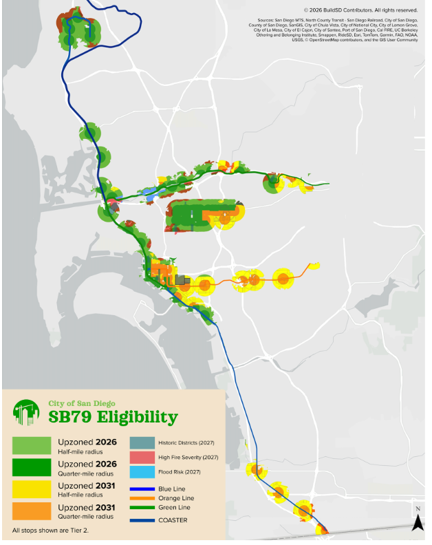
Map: San Diego's updated SB 79 transit-oriented development zones, reflecting SANDAG's revised interpretation, which could add 52 bus stops. Streetsblog California / BuildSD.
Starting July 1, 2026, large swaths of San Diego become eligible for higher-density residential development under California's Senate Bill 79. The city finalized its implementation plan after a May 7 City Council meeting, and SANDAG has since released a draft transit-oriented development map that adds many of the extra bus stops the Council identified, which could bring the total to roughly 103 qualifying transit stops, according to Streetsblog California. That expansion means neighborhoods including Mission Valley, North Park, Hillcrest, and corridors along El Cajon Boulevard and University Avenue are now in scope for immediate upzoning on July 1, rather than waiting until 2027 or later. For a homeowner in any of these neighborhoods who has been thinking about an ADU, the baseline has shifted.
What SB 79 actually does near transit
SB 79 (Wiener), signed by Governor Newsom in October 2025 and taking effect on a phased timeline, requires cities to allow higher residential density within specified distances of high-quality transit stops. All of San Diego's Trolley stations qualify, along with a growing number of bus stops. The radius tiers in the bill, half-mile and quarter-mile zones, determine how much additional density is permitted. San Diego's Trolley stations and qualifying bus stops are classified as Tier 2 under the bill.
For ADU builders specifically: SB 79 changes the underlying zoning baseline, which in some cases expands what is allowed by right on your parcel. If your property is within the eligible radius and now sits in an upzoned area, the conversation with your architect or permit expediter should start from the updated zoning map, not whatever you last looked up. The City of San Diego's SB 79 implementation page has current address lookup tools. Also note: the bill calculates the qualifying radius from each station exit, not the platform center, so larger Trolley stations cover a slightly broader area than a simple circle would suggest.
How 4 bus stops became 52
San Diego's original SB 79 plan listed only 4 bus stops as TOD stops. The reason: SANDAG initially concluded that shared-use bus lanes, which allow turning cars and bikes alongside buses, did not qualify under the bill's definition. That reading would have excluded most of the city's surface bus network from eligibility.
The reinterpretation came after YIMBY Democrats of San Diego County, the Housing Defense Fund, and BuildSD pushed back. BuildSD's contributing writer Sam B. reached out to Senator Wiener's office, which confirmed that shared-use bus lanes do count under SB 79. SANDAG then revised its Draft SB 79 Transit-Oriented Development Map. The result: 52 additional stops on El Cajon Boulevard, University Avenue, and Park Boulevard are now potentially eligible, increasing the total TOD area by nearly 15 percent and bringing North Park, Hillcrest, and adjacent neighborhoods into the July 1 upzoning.
This is one of those cases where the difference between a careful and a careless statutory reading materially changes how many housing units get built. San Diego's implementation is expected to be among the most pro-housing in the state while also being among the most legally defensible, in large part because the city resolved this ambiguity with the bill's author rather than guessing.
The fire risk exemption shrank significantly
San Diego's original plan used the city's own local fire risk map, which is more restrictive than the state's. Under that approach, about 30 percent of the total SB 79 area would have been delayed on fire-risk grounds.
The final plan uses the state fire risk map, as SB 79 requires. The result: the fire-risk delay area dropped from 30 percent to less than 5 percent. Mission Valley, most of the North Trolley Line, and large parts of Mid-City, Old Town, and San Ysidro, which the city's local fire map had flagged as high-risk, are now moving forward for July 1. The remaining fire exemptions apply to single-exit streets and single-exit neighborhoods in state-designated Very High Fire Severity Zones. University City and parts of Clairemont still have some of these. If your street has only one way out and sits in a state VHFSZ, the fire exemption covers you; otherwise, the fire delay is off the table for most San Diego parcels. San Diego's policy on this is consistent with how the city already handles fire risk in the Bonus ADU program, which similarly targets single-exit situations.
What is still delayed or exempt
Historic districts. Properties in historic districts are delayed until Summer 2027. San Diego is not planning a permanent exemption, just a delay while the planning process catches up.
Community plan update areas. Mid-City and Otay Mesa Nestor are both currently receiving new community plans. Those areas will get their SB 79 upzoning as part of the community plan update process in 2027 or 2028, which is actually faster in practice than the standard delayed-area backstop of 2032.
Low Resource Areas. These will be upzoned no later than 2032. San Diego is not adopting a permanent exemption for them.
Flood risk zones. Areas at risk of flooding with a 1-foot sea level rise are delayed until Summer 2027.
One-mile walkshed. Parcels within the half-mile or quarter-mile radius of a qualifying stop but more than one mile away by actual walking route are excluded. Most cities implementing SB 79 are using this provision, since transit-oriented density makes the most sense where people can realistically walk to the station.
The Summer 2027 process. The San Diego Planning Commission is expected to have an alternative TOD map for delayed areas ready by Spring 2027, with City Council adopting it by Summer 2027. That timeline can slip to 2032 at the latest. Many adjustments will happen during that process, and what is decided now is not necessarily the final answer for every parcel in a delayed area.
What San Diego homeowners should do before July 1
If you own property in Mission Valley, North Park, Hillcrest, or near the El Cajon Boulevard or University Avenue corridors, the practical step is to run your address through the city's SB 79 lookup tool before your next conversation with a designer or permit consultant. Your lot's zoning baseline may change on July 1, and a permit conversation based on pre-July 1 zoning may not reflect what is actually permissible after that date. This matters most if you have been told a detached ADU is not feasible on your lot under current zoning, because the calculation changes in areas that are moving forward.
If you want a starting estimate for ADU permit costs under San Diego's current fee schedule, A-du's permit fee calculator covers San Diego as a distinct market from the LA numbers, which matters because the two cities' fee structures differ meaningfully.